
As Mussoorie’s peak summer season approaches — with hotel occupancy rates along the Mall Road expected to climb past 90 percent by late April 2026, according to Uttarakhand Tourism Department projections — a small but growing number of visitors are turning away from the town’s busiest corridors toward the western ridge, where a colonial-era estate and a demanding four-kilometre trail offer something the town’s commercial core largely cannot: unobstructed views and near-total quiet.
The destination is Park Estate, the former home and survey post of Sir George Everest, the Welsh surveyor-general of India whose triangulation work between 1830 and 1843 produced the first accurate measurement of the Indian subcontinent. The mountain that bears his name was identified using data collected in part from this ridge. The Archaeological Survey of India (ASI) maintains the estate ruins, and the Mussoorie-Dehradun Development Authority (MDDA) charges a nominal entry fee at the trailhead.
Where the Trail Starts and How to Get There
The trailhead sits roughly 6 kilometres west of Mall Road, accessible via the Lal Tibba–Clouds End road. From the Library Bus Stand in central Mussoorie, a shared taxi to the Clouds End area costs approximately ₹30–₹50 per seat; a private cab from the same point runs ₹250–₹350 depending on the season and operator, according to rates posted by the Uttarakhand Tourism Department.
Visitors arriving by personal vehicle should note that parking near the trailhead is limited to roughly 10–15 cars on a flat shoulder adjacent to the forest road. During peak season weekends in May and June, that space fills by 9:00 a.m. The MDDA ticket counter opens at 8:00 a.m. and closes at 5:00 p.m.; entry after 4:00 p.m. is generally discouraged by on-site staff due to the return walk in fading light.
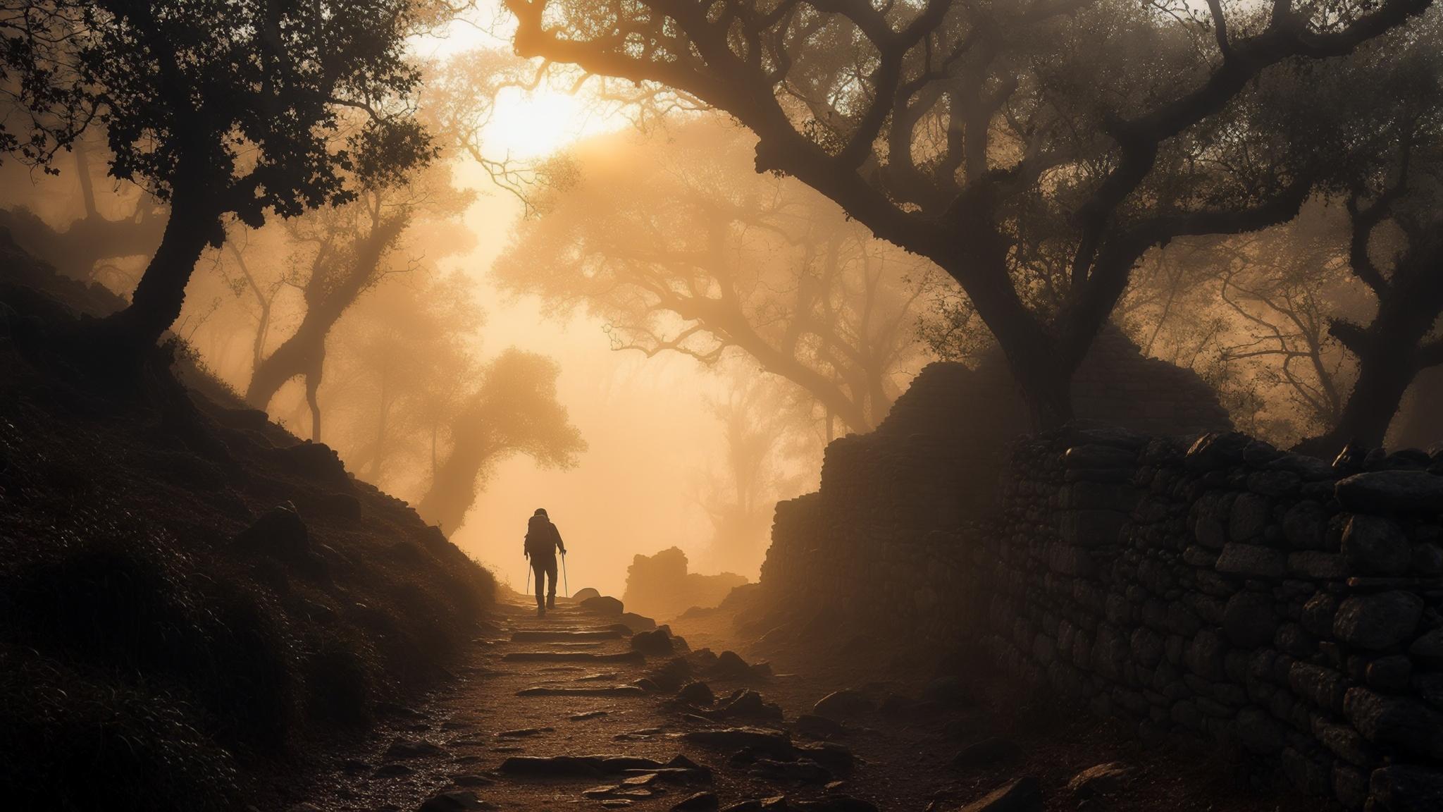
What the Trail Actually Looks Like: Terrain, Gradient, and Distance
The route gains approximately 200 metres of elevation across its four kilometres, classifying it as a moderate hike by Garhwal Himalaya standards — manageable for most adults with reasonable fitness, but not suitable for very young children or visitors with significant mobility limitations. The first two kilometres follow a dirt road through mixed oak and rhododendron forest before narrowing into a single-file footpath.
Between the 2.5km and 3.5km sections, the path opens onto exposed ridgeline with direct views north toward the Bandarpunch range and west toward the Tons River valley. On clear mornings between October and early December — before winter fog settles — visibility can extend to peaks including Swargarohini and, on exceptional days, portions of the Gangotri group, approximately 180 kilometres distant.
The estate ruins at the far end include the stone foundation of Everest’s residence, a restored survey pillar used in the Great Trigonometrical Survey, and a small interpretive panel installed by the ASI in 2019 that outlines the surveying methodology used during the 19th century. The panel is in both Hindi and English. No food or water vendors operate at the site itself — the nearest tea stall is approximately 1.2 kilometres back down the trail.
Best Season to Visit and Month-by-Month Conditions
The trail is accessible across most of the calendar year, but conditions vary significantly by season. October through December offers the clearest skies and most stable footing, with daytime temperatures at the summit typically ranging from 8°C to 15°C. This window is widely regarded by local trekking operators as the optimal period for photography and peak identification.
Monsoon season — June through September — brings the highest risk of trail closures. The MDDA has historically closed the upper section of the path during periods of heavy rainfall, a decision communicated through notices at the ticket counter rather than online channels. Visitors planning a monsoon visit should confirm trail status with their accommodation or directly at the Mussoorie Municipal Office before departing.
How This Compares to Mussoorie’s Other Viewpoints
Mussoorie’s most-visited vantage points — Lal Tibba, Gun Hill, and the Camel’s Back Road — all sit closer to the town centre and command the highest footfall. Gun Hill, accessible by ropeway for ₹150 per person (return), draws several hundred visitors daily during peak season, according to ropeway operator data cited by the Mussoorie Municipal Board. Lal Tibba, the highest point in Mussoorie at 2,275 metres, is freely accessible by road.
The George Everest trail’s practical advantage over these alternatives is the combination of physical engagement, historical context, and relative solitude. On a weekday morning in April 2025, an on-site count conducted by a local trekking association recorded fewer than 40 visitors across the full day — a figure that contrasts sharply with the thousands who pass through Gun Hill or the ropeway section on the same date.
Planning Your Visit: A Step-by-Step Checklist
Visitors combining the George Everest Trail with a broader western-ridge itinerary can pair it with a stop at Clouds End, approximately 1.5 kilometres back toward town, where a colonial-era property now operating as a heritage hotel marks the traditional boundary of the Mussoorie hill station. Entry to the Clouds End grounds is available to non-guests for a nominal fee; the staff has historically been willing to confirm current trail conditions from guests who have just completed the Everest route.
For travellers planning a longer Mussoorie stay, the trail sits naturally in a two-day western-ridge itinerary: day one covering the George Everest route and Clouds End, day two dedicated to Benog Wildlife Sanctuary (approximately 3 kilometres further west), where the Mussoorie Forest Division operates a separate ticketed nature trail through temperate broadleaf forest. The sanctuary is home to the Cheer pheasant, a Schedule I species under India’s Wildlife Protection Act, 1972.