
Fewer than one in ten visitors to Mussoorie — a figure estimated by local trekking operators based on footfall data gathered through the 2024–25 winter season — ever reach George Everest Peak, despite the trailhead sitting roughly 6 kilometres west of the town’s Library Chowk. The summit, at approximately 2,290 metres above sea level, holds the crumbling stone ruins of Sir George Everest’s 19th-century home and field laboratory, and on clear mornings between October and March, it delivers an unobstructed panorama stretching from Bandarpunch in the east to Swargarohini in the north-northwest.
As Mussoorie’s more popular circuits — Kempty Falls, Lal Tibba, and Cloud’s End — grow increasingly crowded in peak season, trekking guides and guesthouse owners in the Hathipaon neighbourhood report a steady uptick in day-hikers specifically seeking the George Everest trail. The route remains unticketted and unmanned, making it one of the few accessible high-altitude walks in the Uttarakhand hill station that carries no entry fee as of March 2026.
Who Was George Everest — and Why Is His House on a Mussoorie Ridge?
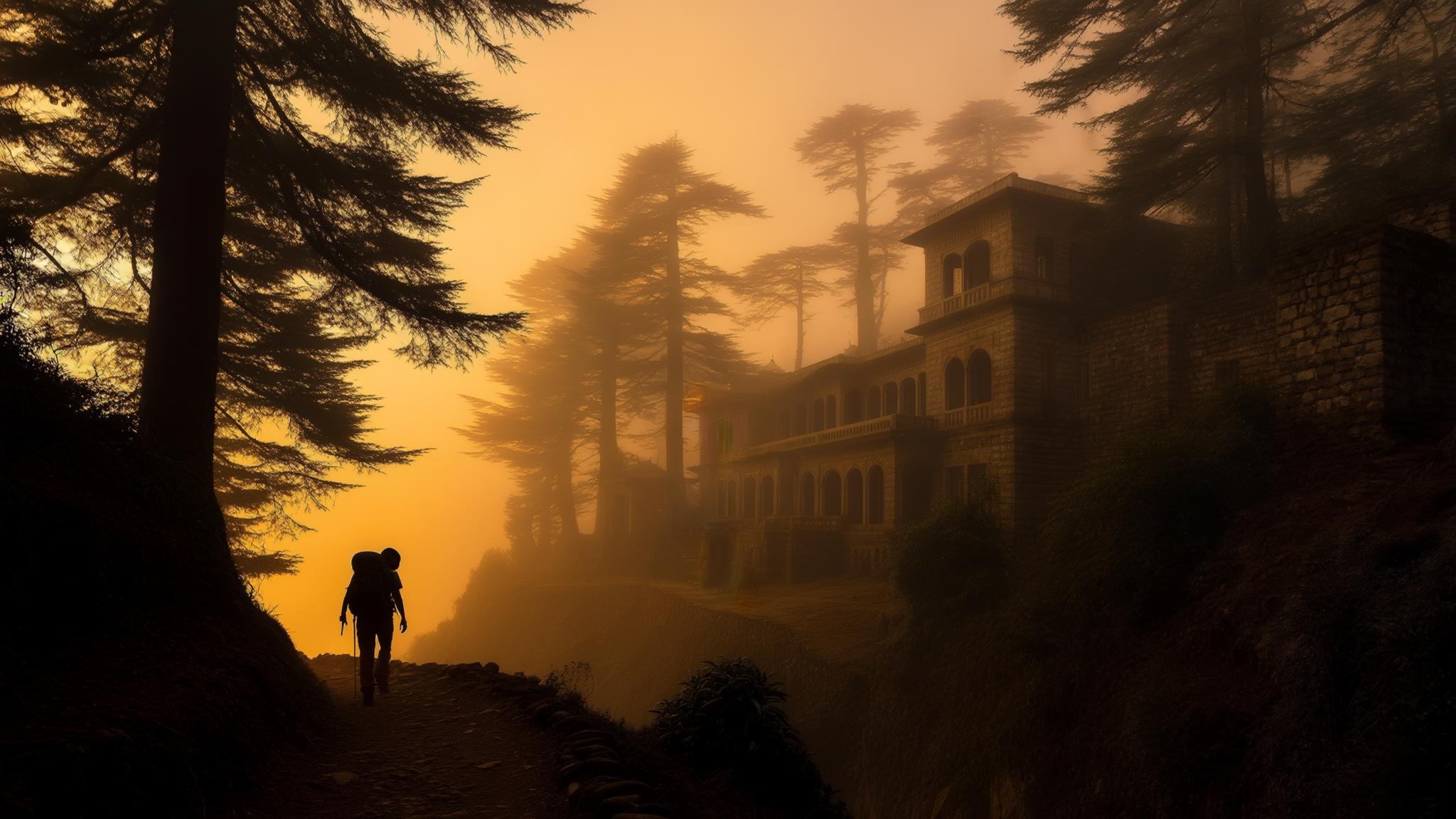
Sir George Everest served as Surveyor General of India from 1830 to 1843 and is credited with completing the Great Trigonometrical Survey of India, a decades-long project to map the subcontinent with unprecedented precision. According to the Survey of India, Everest chose the Hathipaon ridge above Mussoorie as the site of his working estate because its elevation and clear sight lines made it ideal for triangulation measurements across the Himalayan foothills.
The estate — called Park Estate at the time — included a residential bungalow and a separate laboratory building where Everest’s instruments were stored and calibrated. Both structures suffered significant decay in the century following his departure from India in 1843, and today only stone walls and foundation outlines remain. The Archaeological Survey of India lists the site as a protected monument, though active conservation work as of early 2026 remains limited to periodic documentation visits, according to local heritage researchers in Mussoorie.
Mount Everest was named in Everest’s honour in 1865 by the Royal Geographical Society, roughly two decades after the peak — then called Peak XV — was first calculated as the world’s highest point by his successor Andrew Waugh. The naming was controversial at the time because Everest himself reportedly preferred local names for geographical features, a detail noted in records held by the Royal Geographical Society.
The Trail: Distance, Difficulty, and What the Path Actually Looks Like
The standard approach begins at Hathipaon village, accessible by shared taxi or private cab from Mussoorie’s Library Chowk. The road distance from Library Chowk to the Hathipaon trailhead is approximately 5 kilometres by vehicle, taking roughly 15 to 20 minutes depending on traffic — which can be significant on weekends between April and June.
From the Hathipaon trailhead, the path climbs through mixed oak and rhododendron forest before opening onto a ridge that provides early views toward Doon Valley. The trail is largely unpaved and follows a dirt-and-stone track that local guides describe as moderately maintained — clear enough in dry months but potentially slippery and muddied after monsoon rains between July and mid-September.
Trekkers in average fitness typically complete the ascent in 90 minutes to two hours, with the return journey taking approximately 60 to 75 minutes. Guides operating in the area advise a 5:30 a.m. start between October and February to reach the peak before low cloud cover rolls in from the valley, which commonly occurs by 9 a.m. during those months.
Cost Breakdown: What a Realistic Visit to George Everest Peak Costs in 2026
The trek itself is free, but reaching the trailhead and sustaining a day outing from Mussoorie’s main commercial areas involves several expenditures. Based on rates reported by local taxi unions and guesthouses in March 2026, the following figures represent a practical cost range for a solo traveller or small group.
Guides are not mandatory but are widely recommended for first-time visitors, particularly in winter when trail markers can be obscured by snowfall. Rajan Nautiyal, one of several guides operating out of Hathipaon, charges ₹700 for a half-day engagement and can be contacted through the Mussoorie Hotels and Tourism Association, which maintains a registered guide directory.
Best Season and What to Expect at the Summit in Each Month
The peak delivers markedly different experiences depending on the time of year, and seasonal timing significantly affects whether the Himalayan panorama is visible at all. According to observations compiled by Uttarakhand Tourism, Mussoorie’s clearest atmospheric conditions occur between mid-October and the end of February.
At the summit, the ruins of Everest’s estate occupy a relatively flat clearing. On clear winter mornings, peaks including Bandarpunch (6,316 m), Swargarohini (6,252 m), and the Gangotri group are visible to the north and northeast. The Doon Valley floor spreads to the south, with Dehradun city visible on days of low particulate pollution.
There are no facilities at the top — no seating, no waste bins, and no shelter. Trekkers are advised by Uttarakhand Forest Department signage at the trailhead to carry out all waste, a rule that local guides say is honoured inconsistently. Several voluntary clean-up drives have been organised by the Mussoorie Trekkers Collective in the 2024–25 season, according to the group’s social media announcements reviewed by NPP Mussoorie.
Getting to Mussoorie and Onward Planning
Mussoorie is connected to Dehradun — the nearest railhead and airport — by a 35-kilometre road journey that takes approximately 60 to 90 minutes by taxi or bus. Shared taxis from Dehradun’s Gandhi Road stand charge approximately ₹150 to ₹200 per seat as of March 2026; private cabs range from ₹700 to ₹1,000 for the full vehicle.
Travellers arriving by train most commonly use Dehradun Railway Station, which receives direct services from Delhi, Mumbai, and several other major cities. The Shatabdi Express from Delhi’s New Delhi station reaches Dehradun in approximately 5 hours and 30 minutes, with fares starting at roughly ₹750 in chair car class, according to IRCTC’s current schedule.
Accommodation options in the Hathipaon area itself are limited to a handful of small guesthouses and homestays charging approximately ₹800 to ₹2,500 per night. Staying locally eliminates the commute from Mall Road and allows for the early morning start that guides consistently recommend for optimal summit visibility.