
Fewer than 12 percent of tourists who travel to Mussoorie each year make it as far as Cloud’s End, according to estimates cited by the Uttarakhand Tourism Development Board — and an even smaller fraction continue on foot into the Benog Wildlife Sanctuary to reach Benog Tibba. That oversight, local trekking guides say, leaves the vast majority of hill station visitors with a view of the Himalayas filtered through cable car glass rather than from open ridgeline at 2,103 metres above sea level.
The trek to Benog Tibba begins at Cloud’s End, a forested outpost approximately 6 kilometres west of Mussoorie’s Library Chowk, and covers roughly 4.5 kilometres of well-marked trail each way. The sanctuary charges an entry fee of ₹150 for Indian nationals and ₹200 for foreign visitors, as per the Uttarakhand Forest Department’s 2025 rate schedule. No permit beyond the entry ticket is required for day trekkers.
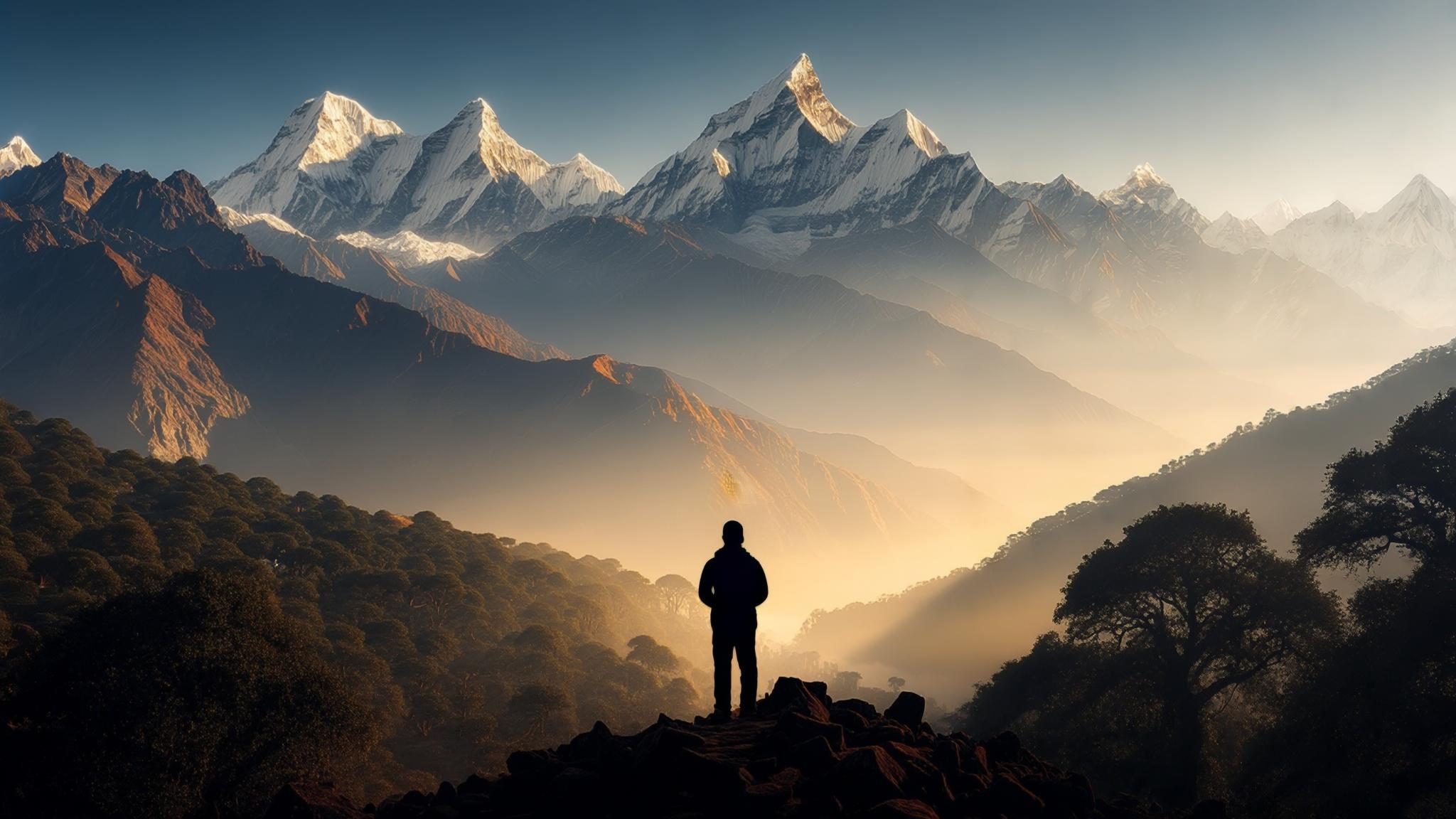
What the Trail Actually Looks Like
The path from Cloud’s End to Benog Tibba is a single, continuous forest trail that passes through dense oak, rhododendron, and pine cover for most of its length. Trail width narrows significantly after the first kilometre, transitioning from a packed-earth fire road to a single-file footpath with intermittent stone steps.
According to local guide Ramesh Negi, who has led treks in the Mussoorie range for over fourteen years, the trail gains approximately 300 metres in elevation from the sanctuary gate to the summit clearing. “The first two kilometres are moderate — anyone in reasonable fitness can handle it,” Negi told NPP Mussoorie. “The last push before the top is steep for about 20 minutes, but the path is clear and there are no technical sections.”
The sanctuary gate opens at 7:00 AM and closes at 5:00 PM year-round, according to posted notices at the Cloud’s End entry point. Forest Department staff stationed at the gate issue handwritten entry slips and conduct a brief head-count log for each group — a protocol introduced in 2023 following a trail safety audit by the state’s forest directorate.
Costs Broken Down for a Solo Trekker and a Group of Four
The financial barrier to completing this trek is, by any measure, low. The primary costs are transportation to Cloud’s End, the sanctuary entry fee, and water. No porters, no guides, and no rented equipment are necessary for the standard day route.
Shared cabs from Gandhi Chowk or Library Bus Stand to Cloud’s End run intermittently throughout the morning and charge approximately ₹60–₹80 per seat for the roughly 20-minute ride, according to drivers operating the route in March 2026. Private taxis charge between ₹250 and ₹350 one-way. No public bus covers the Cloud’s End stretch directly.
A solo trekker completing the full route — cab both ways, entry ticket, two bottles of water purchased at a shop near the sanctuary gate — can expect to spend between ₹450 and ₹600 in total. A group of four sharing a private cab splits transport costs to approximately ₹175 per person round-trip, bringing the per-head total closer to ₹400.
Best Season and What the Weather Actually Does to Visibility
Visibility at Benog Tibba — the defining factor in whether the summit delivers on its reputation — varies sharply by month. March through early June offers the most reliable clear mornings before afternoon cloud cover builds over the valley. The rhododendron forest along the trail also blooms in crimson and pink through April, which local guides cite as the single best month to attempt the walk.
The post-monsoon window of late September through November is consistently cited by experienced trekkers and the Uttarakhand Tourism Development Board as offering the clearest air in the Mussoorie range. Snow-dusted peaks appear closer and more defined after the monsoon washes dust and particulates from the atmosphere.
Wildlife, Flora, and What Trekkers Have Reported Seeing
Benog Wildlife Sanctuary falls under the jurisdiction of the Uttarakhand Forest Department and supports populations of leopard, barking deer, yellow-throated marten, and over 100 species of birds, according to sanctuary records maintained at the Cloud’s End gate. Trekkers are not required to hire a forest guard, but the department recommends groups of at least two people on the trail.
Leopard sightings on the Benog Tibba trail are rare but documented. Forest Department logs reviewed by NPP Mussoorie show three recorded leopard sightings within 500 metres of the main trail between January 2024 and December 2025 — all in early morning hours before 8:00 AM. The department advises trekkers to make moderate noise while walking to avoid surprise encounters.
Bird watchers report consistent sightings of the Himalayan monal — Uttarakhand’s state bird — in the upper reaches of the sanctuary, particularly in the oak belt between the 3-kilometre and 4-kilometre marks on the trail. The Birds of India database lists Benog Sanctuary as one of twelve sites in Garhwal where the monal is reliably observed outside of protected alpine zones.
How Benog Tibba Compares to Mussoorie’s Other Viewpoints
Mussoorie offers several well-known panorama points — Lal Tibba (2,275 m), Gun Hill (2,024 m via ropeway), and the Camel’s Back Road sunrise stretch among them. Each draws significantly larger footfall and higher per-visit costs than the Benog Tibba trail. Gun Hill’s ropeway alone charges ₹150 per person each way, plus separate fees for binoculars hire at the summit, according to the ropeway operator’s 2026 pricing board.
Lal Tibba, at 2,275 metres, is technically higher and houses a Doordarshan transmission tower. Access is free and the road is motorable, but the viewpoint is a paved terrace rather than a natural ridgeline. Benog Tibba at 2,103 metres trades altitude for an unobstructed 180-degree arc free of infrastructure, wires, and vendor stalls — a distinction trekkers who have done both routes consistently note.
For visitors with limited time, the two routes are not mutually exclusive. Lal Tibba is accessible by road in under 30 minutes from Mall Road and serves as a quick orientation. Benog Tibba is a half-day commitment but returns a qualitatively different experience. Both can be completed in a single day if Cloud’s End is prioritised as a morning departure before 8:00 AM.
Mussoorie receives approximately 3.5 million visitors annually, according to figures published by the Uttarakhand Tourism Department. The Benog Sanctuary gate logs suggest fewer than 40,000 trekkers pass through in a full year — a ratio that leaves the trail quiet on most days, even during the peak April and October windows when the town itself is at full capacity.