
As of early April 2026, the trail leading to the George Everest Estate outside Mussoorie is in its clearest seasonal condition — rhododendrons in peak bloom, morning fog dissipating before 9 a.m., and the Himalayan snowline still visible against the northeastern sky. The window for comfortable trekking closes by mid-June when the monsoon arrives, making the next six to eight weeks the most viable period for the roughly 3-hour round-trip walk from Park Estate Road.
The site itself is no secret — it appears in Archaeological Survey of India records as a protected monument — yet it consistently draws a fraction of the visitor traffic that clusters around Kempty Falls or Company Garden. Local guides estimate daily footfall at the estate rarely exceeds 80 visitors on a weekday, compared to several thousand at Mussoorie’s primary commercial attractions.
Who Was George Everest and Why Does His Mussoorie Home Matter
Sir George Everest was the Surveyor General of India from 1830 to 1843 and the man behind the Great Trigonometrical Survey of India — the cartographic project that ultimately calculated the height of the world’s tallest peak, which was named after him posthumously in 1865. He was not, however, present for that naming; Everest had returned to England by 1843 and died in 1866.
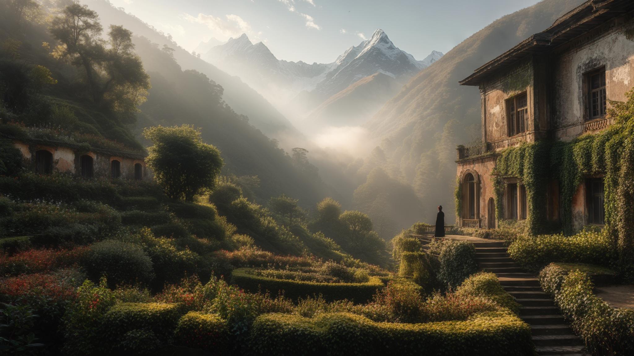
The Mussoorie estate, which Everest constructed beginning in 1832, served dual purposes: a residential home and a working laboratory for his survey operations. The elevation — approximately 2,100 metres above sea level — gave his instruments clear sightlines across the plains to the south and toward the Himalayan range to the north. According to Uttarakhand Tourism, the estate comprises the ruins of two structures: the main residential building and a separate office block used for survey instruments.
The ruins have not been restored to inhabitable condition, which is precisely what makes the site atmospheric. Stone walls stand at varying heights, archways remain largely intact, and the original terraced garden layout is still discernible. The ASI placed the property under protected monument status, meaning no commercial construction is permitted within the buffer zone.
The Trek: What to Expect on the Trail From Park Estate Road
The walk to the George Everest Estate begins at the end of Park Estate Road, accessible from the Library Bus Stand in Mussoorie by shared jeep (approximately ₹30–40 per seat) or by private taxi (₹300–400 one-way). The trailhead is clearly marked with an ASI signboard, though the path itself is unpaved and involves a moderate elevation gain over the final kilometre.
The full round trip covers approximately 6 kilometres and takes between 2.5 and 3.5 hours depending on pace. The trail passes through mixed oak and rhododendron forest, with two rest points offering benches and partial valley views. No dedicated food stalls operate on the trail itself, though a small chai vendor typically sets up near the trailhead on weekends.
Trekkers with moderate fitness levels report no significant difficulty. The steepest section — a roughly 200-metre rocky climb near the estate boundary — takes about 20 minutes. Children above age 8 typically complete the trail without issue, according to visitor accounts compiled by the Landour Community Hall’s heritage walk program.
The View: What the Estate’s Panorama Actually Shows
The view from the estate’s upper terrace is the primary draw for most visitors who make the trip. On a clear morning — which April and May reliably offer before midday cloud build-up — the panorama spans from Bandarpunch (6,316 metres) in the northwest to the Gangotri range in the northeast. Srikanta, Gangotri I, and Kedarnath peaks are all identifiable from this vantage point on clear days.
To the south, the Doon Valley spreads across the full width of the view, with Dehradun visible as a grey-green smear in the middle distance. The valley floor sits at roughly 700 metres, creating a vertical differential of about 1,400 metres from the estate — enough to generate a pronounced sense of height that many visitors describe as more dramatic than Lal Tibba, Mussoorie’s designated highest point open to public access.
How to Plan a Visit: Costs, Timing, and Practical Logistics
April 2026 conditions are favourable. Daytime temperatures at the estate hover between 12°C and 19°C during morning hours, dropping sharply after 4 p.m. Visitors who reach the trailhead by 7:30 a.m. typically have the ruins to themselves for the first hour. By 11 a.m. on weekends, small groups of 10–15 people are common, though the site never approaches the congestion levels of central Mussoorie attractions.
For visitors staying in Mussoorie, the easiest approach is a shared jeep from Library Chowk toward Hathipaon or Park Estate, asking to be dropped at the George Everest trailhead. The journey takes approximately 20 minutes. Return transport requires either a pre-arranged pickup or flagging a passing vehicle on the main road, which local guides confirm is manageable but not guaranteed in under 30 minutes during off-peak hours.
The total cost for a solo visitor — shared jeep both ways, ASI entry fee, and a meal at Landour — comes to approximately ₹400–600. For a couple or small group using a private taxi for convenience, the day’s transport budget rises to ₹700–900, still well below most comparable heritage day-trip options in the Uttarakhand hills.
Garhwal Mandal Vikas Nigam (GMVN), the state tourism body, does not currently operate a dedicated guided tour to the George Everest Estate, though independent licensed guides available at Library Chowk charge approximately ₹500–800 for a half-day heritage walk that includes the estate and Landour Bazaar. According to GMVN’s official site, heritage circuit packages in the Mussoorie region are under review for expansion in the 2026–27 tourism calendar.
For visitors arriving between now and late May, the George Everest Estate represents one of the most cost-efficient and historically substantive half-days available within the Mussoorie municipality limits — an assessment shared by heritage conservation advocates and the local guide community alike.