
When was the last time you visited a hill station and actually felt alone with the mountains? For most travellers arriving in Mussoorie in the spring or summer, the answer is probably never — the town’s famous promenade sees an estimated 15,000 to 20,000 visitors on peak weekend days, according to local tourism estimates. But roughly 8 kilometres west of the Mussoorie clock tower, a different Mussoorie exists entirely.
The Benog Wildlife Sanctuary trail, which begins near Cloud’s End and climbs to the Benog Hill trig point at approximately 2,240 metres above sea level, is drawing a steady stream of hikers, birdwatchers, and photographers who want something the main tourist circuit cannot offer: silence, forest cover, and an unobstructed view of peaks including Bandarpunch and the Gangotri range on clear mornings.
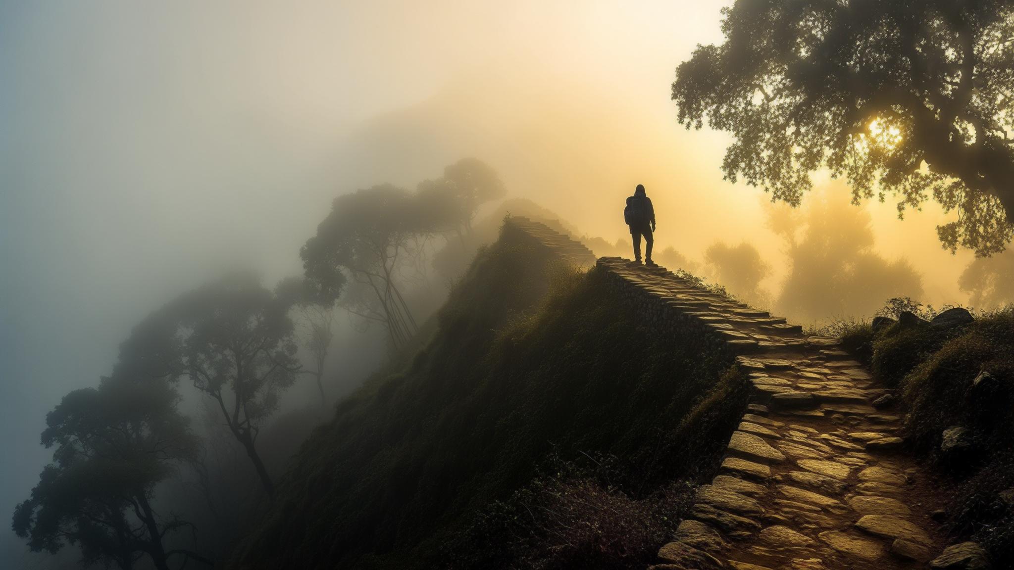
What the Benog Hill Trail Actually Looks Like
The trail is not a hidden secret in the classical sense — it appears on most detailed topographic maps of the Mussoorie range, and the Uttarakhand Forest Department maintains a checkpost at the sanctuary entrance near Cloud’s End. What keeps visitor numbers low is a combination of geography and reputation: the trailhead is a ₹150–₹200 shared taxi ride from Gandhi Chowk, and the hike demands a genuine two to three hours of walking on uneven forest paths rather than the paved promenades most leisure tourists prefer.
From the Cloud’s End forest checkpost, the main trail climbs steadily through mixed oak and rhododendron forest for approximately 3.5 kilometres before reaching the Benog Hill summit, which is marked by a small Durga temple and a Forest Department observation point. The gradient is moderate — experienced walkers describe it as comparable to a brisk hill walk rather than a technical climb — but the path can become slippery during and after rainfall.
The return route can be varied by looping back through the lower forest road toward Cloud’s End estate, adding roughly 1.5 kilometres but reducing the steep downhill gradient that beginners find difficult on tired legs.
Birdwatching: The Reason Many Repeat Visitors Come Back
For a significant subset of visitors, the Himalayan views are secondary. The Benog Wildlife Sanctuary has been documented by the Birds of India birding community as one of the more accessible spots in Uttarakhand for observing mid-elevation Himalayan species, including the Himalayan monal — the state bird of Uttarakhand — as well as cheer pheasant, khalij pheasant, and a range of laughingthrush species.
The best birdwatching window is widely reported as 6:00 a.m. to 9:00 a.m., which means hikers who want to combine summit views with wildlife observation need to start from Mussoorie no later than 5:30 a.m. during summer months. Accommodation on the western ridge — including the historic Cloud’s End property — makes an early start logistically straightforward for overnight visitors.
How to Plan the Hike: Costs, Timing, and Logistics
Planning the Benog trail requires more forward thinking than most Mussoorie day activities, but the logistics are manageable. The essential costs are modest compared to other Mussoorie experiences.
- Shared taxi from Gandhi Chowk to Cloud’s End: approximately ₹150–₹200 per seat (private taxi ₹500–₹600 one way)
- Sanctuary entry fee: approximately ₹150 per person for Indian nationals; foreign nationals are charged a higher rate, typically ₹600, according to Forest Department schedules
- Guide hire (optional but recommended for first-timers): ₹400–₹700 for a half-day, sourced through the forest checkpost or registered local operators
- Water and snacks: no vendors operate inside the sanctuary boundary, so hikers must carry their own supplies
The best months for clear Himalayan views are October through early December and late February through April. April is particularly striking because the rhododendron trees along the upper trail are in full bloom, creating a red and pink canopy over the path. Summer months (May–June) are viable but haze typically reduces long-range visibility from the summit by late morning.
Cloud’s End: The Starting Point With Its Own History
The western edge of Mussoorie, where the trail begins, carries its own historical weight. Cloud’s End is the name of both a colonial-era estate and the geographic point where Mussoorie’s ridge effectively terminates before dropping steeply into the Aglar River valley below. The property has operated as a heritage hotel for decades, and its forested grounds — which abut the sanctuary boundary — are among the most intact private landholdings on the Mussoorie ridge.
According to local historians, the Cloud’s End area was used as a retreat by British officers stationed in Landour cantonment during the colonial period. The dense oak forest that gives the sanctuary its character today is partly a legacy of deliberate conservation decisions made during that era, when the western ridge was kept free of the dense construction that eventually transformed central Mussoorie.
What the Trail Means for Mussoorie’s Tourism Future
The Benog trail sits within a broader conversation about how Mussoorie manages visitor pressure. The Uttarakhand Tourism Development Board has, in various policy documents, flagged the need to distribute tourist footfall away from the Mall Road–Kempty Falls corridor, which accounts for the overwhelming majority of visitor activity in the district. Trails like Benog represent what urban planners sometimes call dispersal infrastructure — low-cost, high-value experiences that can absorb visitor numbers without requiring major capital investment.
According to reporting by The Times of India, Mussoorie received approximately 35 lakh (3.5 million) visitors in 2024, a figure that has placed significant strain on road infrastructure, water supply, and waste management in the main township. Any mechanism that redirects even a fraction of that footfall toward regulated forest trails has tangible environmental value.
For a town that has, at various points, been called overcrowded and overdeveloped, Benog Hill offers a counterargument in forest form. The trail is not a solution to Mussoorie’s tourism pressures, but it is a reminder that the landscape beyond the promenade remains intact, accessible, and worth the extra effort to reach.