
What would it take for a trail with panoramic views of the Bandarpunch massif, Swargarohini, and the Gangotri range to remain almost entirely off the tourist radar — a short drive from one of India’s most visited hill stations? At George Everest Peak, roughly six kilometres west of Mussoorie’s Library Chowk, that question answers itself the moment a visitor arrives and finds the ruins of Sir George Everest’s 19th-century field headquarters standing largely alone against the sky.
The peak, sitting at approximately 2,104 metres above sea level, is named after the Surveyor General of India who directed the Great Trigonometrical Survey from this ridge between 1832 and 1843. Everest’s team used the location to triangulate measurements that eventually determined the height of Peak XV — later renamed Mount Everest in his honour. The stone structures of his laboratory and residence still stand, maintained intermittently by the Archaeological Survey of India.
What the Trail Actually Looks Like on the Ground
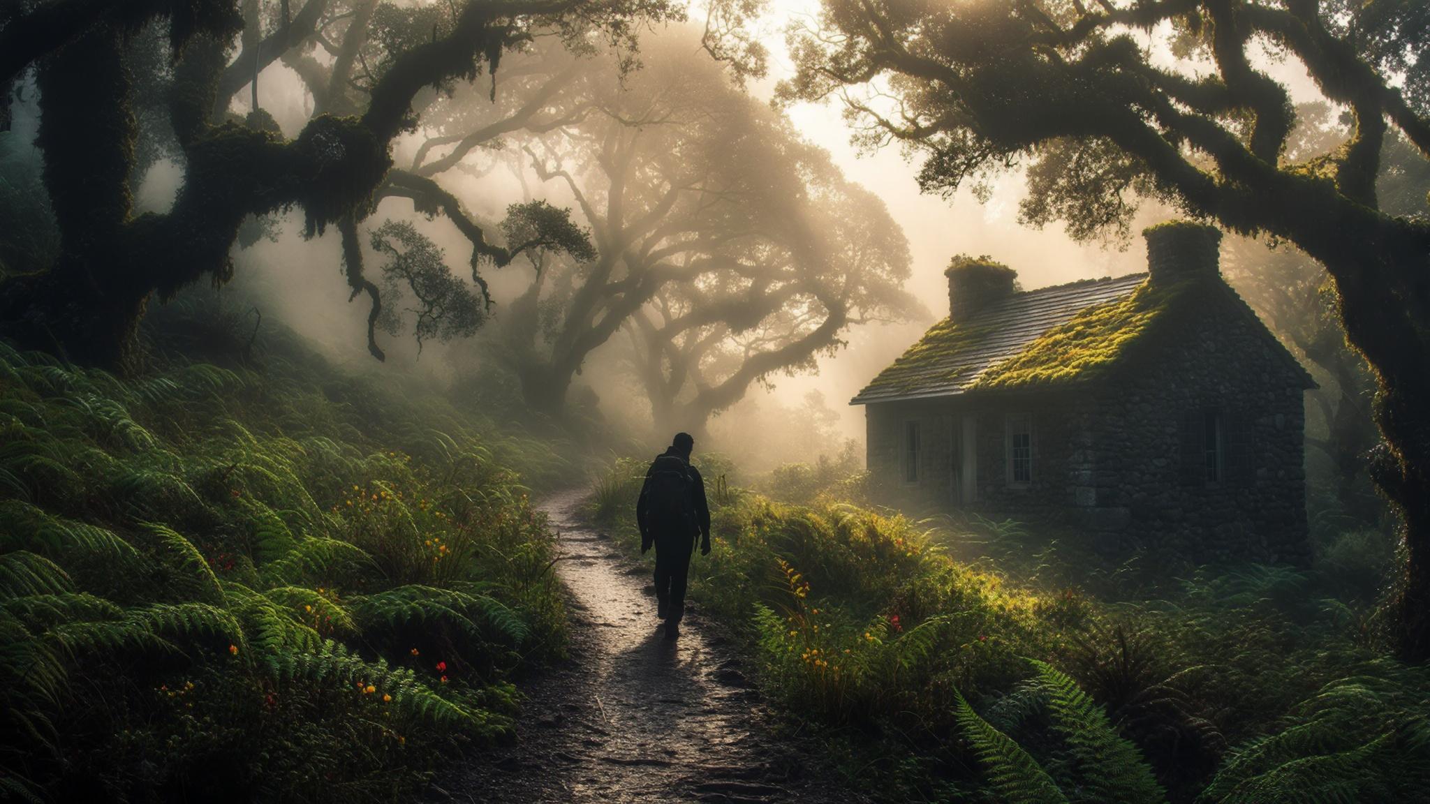
The trek begins at Park Estate, a neighbourhood on the western edge of Mussoorie accessible by shared taxi from Library Chowk for roughly ₹30–₹50 per seat. From Park Estate, a jeep track transitions into a walking path that follows the ridge westward. The gradient is moderate — there are no technical sections — but the trail does involve sustained elevation gain across loose stones in several stretches, making proper footwear important.
The path passes through mixed oak and rhododendron forest for the first three kilometres. In March and April, rhododendron blooms make this section particularly photogenic. The forest thins as the trail approaches the final ridge, and the ruins of Everest’s two stone buildings become visible approximately 200 metres before the summit plateau.
The summit plateau is broad and grassy, with the two-storey stone residence and the separate laboratory building occupying the northern edge. The view corridor to the north and northeast takes in a long sweep of the greater Himalayan range on clear days, with Bandarpunch (6,316 m) identifiable as the dominant peak to the northeast. Local trekking operators in Mussoorie describe the George Everest viewpoint as offering a wider Himalayan panorama than either Gun Hill or Lal Tibba, both of which draw far larger crowds.
The History Behind the Name — and Why It Matters for the Visit
Understanding who George Everest was adds a dimension to the visit that no viewpoint on Mall Road can match. Sir George Everest (1790–1866) served as Surveyor General of India from 1830 to 1843. The Great Trigonometrical Survey he directed was, according to historians of science, one of the most ambitious mapping projects in human history — an attempt to measure the entire Indian subcontinent with geodetic precision using triangulation from fixed baselines.
The Mussoorie ridge was chosen as a base for survey operations because of its commanding elevation and clear sight lines toward the Himalayan range. Everest’s field headquarters here were not a residence in the conventional sense but a working scientific installation, equipped with instruments and staffed by surveyors who remained on-site for months at a time. The larger stone building served as the residential quarters; the smaller structure housed the instruments and served as the computational lab.
Peak XV was first identified as the highest point on Earth in 1852 by the Survey of India under Everest’s successor, Andrew Waugh. Waugh proposed naming it after Everest in 1856, a decision that was formalised officially. The mountain’s Nepali name, Sagarmatha, and Tibetan name, Chomolungma, both predate the colonial designation, a point that contemporary historians and Nepali geographers have repeatedly noted in academic literature.
Practical Planning: Costs, Timing, and What to Carry
The George Everest Peak trek requires no advance booking, no entry fee, and no permits as of the date of this report. The entire excursion, including transport from Mussoorie’s Library Chowk, can be completed for under ₹500 per person — making it among the most cost-effective half-day activities available in the region.
The best months to attempt the trek are October through April. Summer months (May and June) see haze that significantly reduces Himalayan visibility. The monsoon season (July through mid-September) renders the trail slippery and increases leech exposure in the forested sections. Winter months from November through February offer the clearest mountain views but require warm layers, as temperatures at the peak can drop below 5°C even on sunny afternoons.
Visitors should carry at minimum two litres of water per person and a packed lunch or substantial snacks. There are no food or water vendors anywhere on the trail, and the nearest dhaba is back at Park Estate. According to trekking operators in Landour, starting before 8 AM on clear winter days provides the best visibility window before afternoon cloud development obscures the high Himalayan peaks.
The Condition of the Ruins and Conservation Questions
The two stone structures at George Everest Peak are officially protected monuments under the Archaeological Survey of India. In practice, maintenance has been inconsistent. A 2019 report by the Mussoorie-based heritage group Mussoorie Heritage Centre documented significant structural deterioration in the roof sections of the residential building, with partial collapse visible in the eastern wall.
Visitors to the site in early 2026 have reported that the interior of the main building is accessible but structurally unstable in sections. Entering the buildings is not advisable, and signage at the site currently does not restrict access. The Uttarakhand Tourism Development Board had not, as of the date of this report, issued any updated guidelines specific to the George Everest Peak site regarding visitor safety protocols inside the ruins.
The broader implication for travellers is straightforward: the site is worth visiting now, precisely because it remains undeveloped and uncrowded. If and when formal tourism infrastructure arrives — ticketing, guided circuits, souvenir stalls — the character of the place will change. According to Archaeological Survey of India records, the site is listed as a protected monument under the Ancient Monuments and Archaeological Sites and Remains Act, though active restoration timelines for the Mussoorie site have not been publicly announced.
For visitors combining the trek with a wider Mussoorie itinerary, the George Everest Peak half-day pairs well with an afternoon on Camel’s Back Road or a visit to the Landour Bazaar — both within a short taxi ride of Park Estate. According to Uttarakhand Tourism, Mussoorie receives approximately 3.5 million visitors annually, the overwhelming majority of whom concentrate their time on Mall Road and Kempty Falls. The George Everest trail, by contrast, sees visitor numbers that local guides estimate at well under 10,000 per year — a figure that underscores how effectively the site’s relative obscurity has persisted despite its proximity to one of India’s busiest hill-station circuits.
Frequently Asked Questions
{“@context”:”https://schema.org”,”@type”:”FAQPage”,”mainEntity”:[{“@type”:”Question”,”name”:”How far is George Everest Peak from Mussoorie Mall Road?”,”acceptedAnswer”:{“@type”:”Answer”,”text”:”George Everest Peak is approximately 6 km west of Library Chowk, Mussoorie. The trailhead at Park Estate is reachable by shared taxi for ₹30–₹50 per seat.”}},{“@type”:”Question”,”name”:”Is there an entry fee for George Everest Peak in 2026?”,”acceptedAnswer”:{“@type”:”Answer”,”text”:”As of March 2026, there is no entry fee to access the George Everest Peak trail or the ruins. The site is a protected monument under the Archaeological Survey of India but no ticketing system was in operation.”}},{“@type”:”Question”,”name”:”What is the best time of year to trek to George Everest Peak?”,”acceptedAnswer”:{“@type”:”Answer”,”text”:”October through April offers the clearest Himalayan views. The monsoon season (July to mid-September) makes the trail slippery and increases leech exposure. Winter mornings before 8 AM on clear days are considered optimal for mountain visibility.”}},{“@type”:”Question”,”name”:”How long does the George Everest Peak trek take?”,”acceptedAnswer”:{“@type”:”Answer”,”text”:”Most moderately fit adults complete the 6 km one-way trail in 2 to 2.5 hours, making the full round trip 3.5 to 5 hours including time at the ruins and rest stops.”}},{“@type”:”Question”,”name”:”Who was George Everest and why is the Mussoorie peak named after him?”,”acceptedAnswer”:{“@type”:”Answer”,”text”:”Sir George Everest (1790–1866) served as Surveyor General of India from 1830 to 1843 and directed the Great Trigonometrical Survey from this Mussoorie ridge starting in 1832. His survey work eventually led to the measurement of Peak XV, renamed Mount Everest in his honour in 1856.”}}]}