
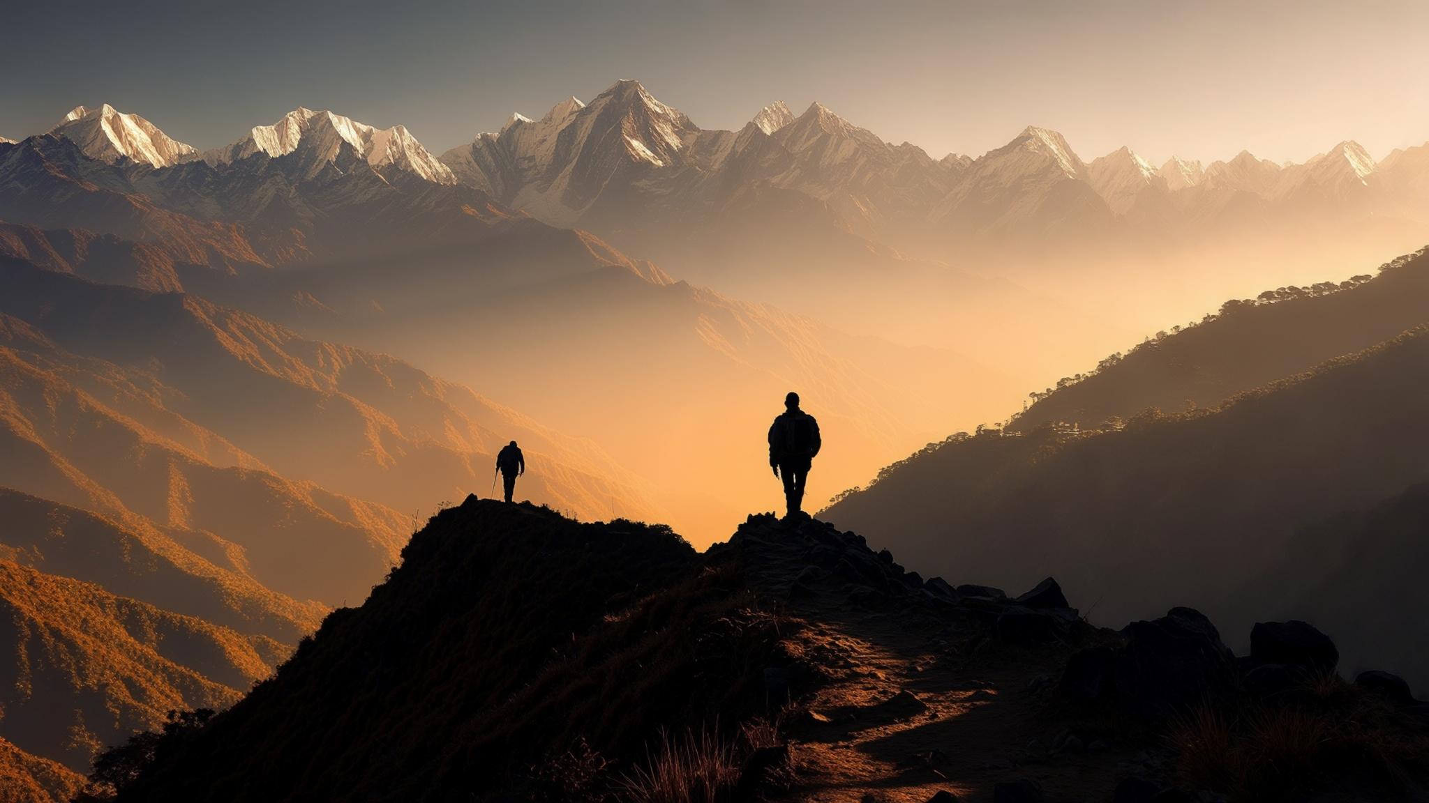
When did you last choose a crowd over a view — and realise it only once you were already there? Every weekend, thousands of visitors to Mussoorie funnel toward the same three or four landmarks, while a marked forest trail eleven kilometres from the town centre sits almost entirely empty. That trail leads to Benog Tibba, a forested ridge-top at approximately 2,290 metres that, on a clear morning, frames the snow-covered summits of Bandarpunch, Kedarnath, Badrinath, and Chaukhamba without obstruction.
Benog Wildlife Sanctuary, the protected area through which the route passes, covers roughly 239 hectares of oak, rhododendron, and mixed temperate forest on Mussoorie’s western flank. The Uttarakhand Forest Department administers the sanctuary and maintains the primary trail, which originates near the historic Clouds End property on Hathipaon Road. The circuit is classified as a moderate hike and is considered suitable for reasonably fit adults and older children, according to local trekking operators based in Mussoorie.
What the Trail Actually Involves
The route begins at the Clouds End Forest Gate on Hathipaon Road, where the Uttarakhand Forest Department collects an entry fee. As of March 2026, the entry fee stands at ₹100 per person for Indian nationals and ₹300 for foreign nationals, according to signage at the gate confirmed by this reporter during a site visit this month. Cameras require a separate permit of ₹50.
From the gate, the trail climbs steadily through mixed oak and rhododendron forest for approximately four kilometres before reaching the Benog Tibba summit area. The rhododendrons bloom between late February and early April, coating the upper slopes in deep red — a detail that makes the March–April window particularly popular among photographers and birdwatchers.
The descent follows the same route back to Clouds End, though some local guides lead groups on an extended loop via Lal Tibba Road for an additional two kilometres. The trail surface is mostly packed earth with some rocky sections near the summit; trekking shoes with grip are strongly advised, particularly after rain.
The Wildlife That Makes This Route Distinctive
Benog Wildlife Sanctuary is formally recognised as one of the richest birding sites in the Garhwal Himalayan foothills. The Bombay Natural History Society has documented over 100 bird species within or immediately adjacent to the sanctuary, including the Himalayan monal — Uttarakhand’s state bird — cheer pheasant, kalij pheasant, and multiple species of woodpecker and warbler.
Mammal sightings, while less frequent during daytime hours, include barking deer, Himalayan goral, and leopard. The Forest Department advises hikers to stay on marked trails, avoid hiking alone in the early morning or after 4:00 p.m., and refrain from carrying food openly. No significant human-wildlife conflict incidents involving trekkers have been publicly reported in recent seasons, according to the Mussoorie Forest Range office.
Getting There and What It Costs
Hathipaon Road, which leads to the Clouds End gate, is accessible by shared taxi from the Library Bus Stand in Mussoorie. As of March 2026, the shared taxi fare for this route is approximately ₹30–50 per seat. A private cab or auto-rickshaw for the same journey costs between ₹250 and ₹400 depending on negotiation and time of day.
There is no food stall inside the sanctuary, and the nearest teahouse is located at the Clouds End property, which operates a café open to non-guests. Hikers are required to carry their own water; a minimum of one litre per person is recommended for the return journey, with 1.5 litres advisable in warmer months.
A registered local guide is not mandatory for the Benog circuit but is recommended for first-time visitors unfamiliar with the trail. The Mussoorie Trekkers Association maintains a list of certified guides, available at the Mussoorie Municipal Office on The Mall Road. Guides charge approximately ₹600–900 for a half-day outing for groups of up to six people.
Best Season and Practical Timing
The Benog Tibba trail is open year-round, but conditions vary significantly by season. The most consistent window for both clear Himalayan views and comfortable walking temperatures runs from mid-September through mid-November and again from late February through early June.
Sunrise hikes, which require reaching the gate by approximately 6:30 a.m. during summer months, offer the clearest mountain views before valley haze builds. Several Mussoorie guesthouses — particularly those in the Landour and Hathipaon areas — offer early breakfast service to accommodate trekkers departing before 7:00 a.m.
Why This Trail Remains Relatively Quiet
Mussoorie receives approximately 30–35 lakh tourists annually, according to Uttarakhand Tourism figures. Of that number, only a small fraction make the journey to Benog — a pattern that local guides and conservation workers attribute partly to a lack of organised promotion and partly to the trail’s distance from the central Mall Road corridor.
The Uttarakhand Forest Department has not developed significant visitor infrastructure within the sanctuary beyond basic trail marking and the entry gate, a deliberate policy choice to limit footfall and protect the habitat. That restraint has preserved the trail’s character but has also kept it off the radar of package tour operators, who tend to favour sites with parking facilities and souvenir shops.
For travellers willing to invest half a day and a moderate level of physical effort, the Benog Tibba circuit offers what the more commercialised Mussoorie itinerary rarely delivers: silence, forest cover, and an unobstructed Himalayan horizon that requires no paid viewpoint tower to access. The total out-of-pocket cost for a solo Indian traveller, including transport, entry, and a guide, sits below ₹1,200 — a fraction of what a cable car ride to Gun Hill charges for a less expansive view.
Frequently Asked Questions
{“@context”:”https://schema.org”,”@type”:”FAQPage”,”mainEntity”:[{“@type”:”Question”,”name”:”How do I reach the Benog Tibba trail from Mussoorie town?”,”acceptedAnswer”:{“@type”:”Answer”,”text”:”Take a shared taxi from Library Bus Stand in Mussoorie to Hathipaon Road, which costs approximately ₹30–50 per seat as of March 2026. The Clouds End Forest Gate, where the trail begins, is about 11 km from the town centre.”}},{“@type”:”Question”,”name”:”What is the entry fee for Benog Wildlife Sanctuary?”,”acceptedAnswer”:{“@type”:”Answer”,”text”:”As of March 2026, the Uttarakhand Forest Department charges ₹100 per Indian national and ₹300 per foreign national at the Clouds End gate. A camera permit costs an additional ₹50.”}},{“@type”:”Question”,”name”:”Is the Benog Tibba trek safe for families with children?”,”acceptedAnswer”:{“@type”:”Answer”,”text”:”Local trekking operators classify the route as moderate and suitable for older children and reasonably fit adults. The Forest Department advises against hiking alone in early morning or after 4:00 p.m. due to wildlife activity, particularly leopard presence in the sanctuary.”}},{“@type”:”Question”,”name”:”What is the best time of year to do the Benog trek?”,”acceptedAnswer”:{“@type”:”Answer”,”text”:”The most reliable windows are mid-September to mid-November and late February to early June. March and April are particularly scenic due to blooming rhododendrons. Monsoon months (July–August) bring trail erosion and leeches and are discouraged by Forest Department staff.”}},{“@type”:”Question”,”name”:”Do I need a guide for the Benog Tibba circuit?”,”acceptedAnswer”:{“@type”:”Answer”,”text”:”A registered guide is not mandatory but is recommended for first-time visitors. The Mussoorie Trekkers Association provides certified guides at approximately ₹600–900 per half-day for groups of up to six people. A guide list is available at the Mussoorie Municipal Office on Mall Road.”}}]}