
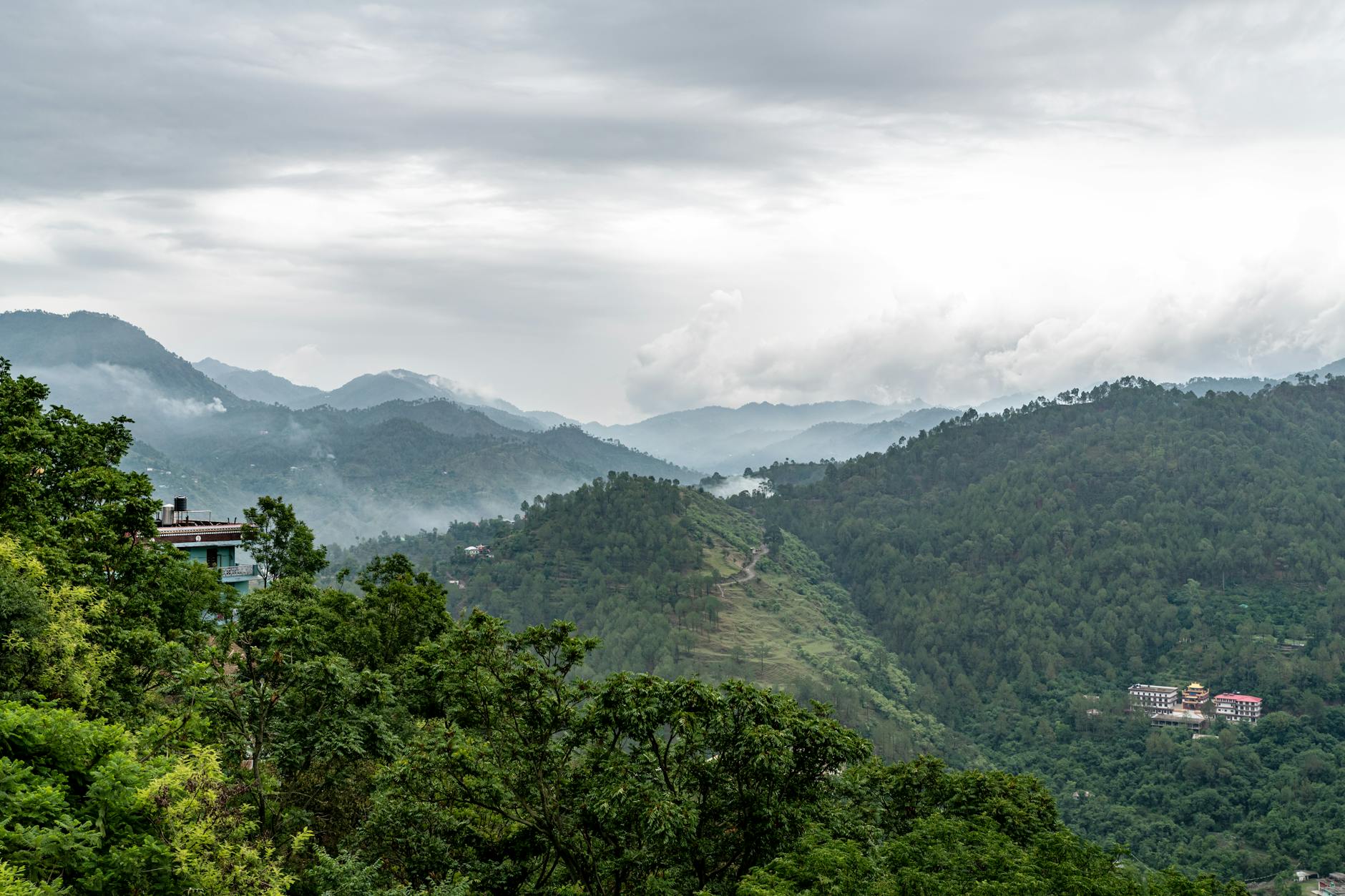
Mussoorie draws an estimated 15 lakh tourists annually, according to Uttarakhand Tourism Department figures, yet roughly 92% of those visitors never walk beyond the Camel’s Back Road. The trail to George Everest Peak — locally called Hathi Paon, meaning ‘elephant’s foot’ for the ridge’s silhouette — sits just 6 kilometres from the Mall Road clock tower, costs nothing to access, and delivers unobstructed views of the Aglar River valley and the first Himalayan ridgeline that most paid viewpoints in town cannot replicate.
The site combines two draws rarely found on the same trail in Uttarakhand: a documented piece of colonial scientific history and a genuine sub-alpine forest walk. The stone building at the summit once served as the home and observatory of Sir George Everest, the Surveyor General of India credited with completing the Great Trigonometrical Survey of India between 1830 and 1843. The Archaeological Survey of India (ASI) lists the structure as a protected monument, and a small interpretation board maintained by ASI marks the approach.
The Route: What the Trail Actually Looks Like
The trail begins near the Park Estate gate, accessible from the Char Dukan junction on the western end of Mall Road. From Char Dukan, most walkers either proceed on foot along the Camel’s Back Road for approximately 2 km to reach the forest path, or take a shared jeep to the Park Estate intersection for ₹30–₹50 per seat. The full return journey on foot from Char Dukan covers roughly 12–13 km and takes between four and five hours at a moderate pace.
The forest section of the trail passes through mixed oak and rhododendron canopy managed under the Mussoorie Forest Division. The path is unpaved for most of its length and narrows considerably after the Park Estate gate. There are no food stalls beyond Char Dukan on this route, making it important for visitors to carry water and snacks from town.
Costs and Logistics: A Realistic Budget Breakdown
The Hathi Paon trail has no entry fee and no permit requirement as of March 2026, verified against the Mussoorie Municipal Council’s current notification list. The primary costs are transport to and from the trailhead and food carried from Mussoorie town.
A solo traveller completing the full day — shared taxi to trailhead, packed lunch from a Landour bakery, and return taxi — can expect total expenditure between ₹200 and ₹400, depending on food choices. Landour Bakehouse near Tehri Road, one of the most cited provisions stops by returning trekkers, charges ₹60–₹120 for sandwiches and ₹40 for a 500ml water bottle, according to its current displayed menu.
- Shared jeep (Library to Park Estate junction): ₹30–₹50 per seat, both directions
- Private taxi (round trip, waiting included): ₹600–₹900 depending on vehicle and season
- Packed lunch from Char Dukan or Landour: ₹150–₹300 per person
- Water (2 litres recommended): ₹40–₹80 from Char Dukan shops
- Entry fee: ₹0
The George Everest Connection: What the Monument Records
Sir George Everest used the Hathi Paon estate as a base of operations from approximately 1832, during the final phases of the Great Trigonometrical Survey. The estate’s elevation — approximately 2,290 metres above sea level — gave survey teams uninterrupted sightlines toward the plains and toward the central Himalayan range. According to the Archaeological Survey of India, the property consists of two main stone structures: the residential building and a laboratory block, both now in partial ruin but structurally stabilised under ASI conservation work completed in 2018.
Everest himself is recorded as having lived on the property intermittently until 1843. The mountain he is named after — known as Sagarmatha in Nepali and Chomolungma in Tibetan — was formally designated ‘Peak XV’ by the Survey of India in 1847 and renamed in his honour in 1865, more than two decades after he retired from the survey, a detail the ASI interpretation board at the site documents in full.
Best Season and Weather Conditions
Trail conditions vary significantly across Mussoorie’s seasons. The Forest Division’s publicly available advisories categorise the route as accessible year-round but flag two distinct risk windows: the monsoon period (mid-June through mid-September), when the clay-soil sections become slippery and leeches are present in the undergrowth, and the deep winter window (December through early February), when sub-zero morning temperatures and occasional ice patches on the north-facing sections demand appropriate footwear.
October through November is widely cited by local guides as the optimal period: post-monsoon clarity allows views across to Bandarpunch and, on cloudless mornings, to Kedarnath’s ridgeline. Spring (March through May) is the second-recommended window, with Himalayan rhododendron in full red bloom along the forest section of the route.
What Travellers Actually Find at the Summit
At the trail’s end, visitors reach a flat grassy plateau at approximately 2,290 metres. The ASI-maintained ruins of Everest’s residential building occupy the southern edge. A rough stone boundary wall marks the original estate perimeter. The plateau itself provides 270-degree views: the Doon Valley to the south, the Aglar River gorge to the west, and the main Garhwal Himalayan range to the north and northeast.
There are no toilets, no food vendors, no seating infrastructure, and no mobile signal on the Airtel and Vi networks along the final kilometre of the trail, based on field observations by this correspondent during a site visit in February 2026. Jio users reported one bar of signal intermittently at the summit plateau itself.
The trail to George Everest Peak does not require advance booking, a guide, or specialist equipment. What it does require is an early start, adequate water, and the willingness to spend half a day away from the cable cars and the caramel popcorn stalls of Mall Road. For the roughly 8% of visitors who currently make that choice, the reward is a site that connects Mussoorie’s present-day tourism economy to the 19th-century scientific project that put the Himalayas on the world map — accessed, for now, entirely for free.
Frequently Asked Questions
{“@context”:”https://schema.org”,”@type”:”FAQPage”,”mainEntity”:[{“@type”:”Question”,”name”:”Is the George Everest Peak trail in Mussoorie free to enter?”,”acceptedAnswer”:{“@type”:”Answer”,”text”:”As of March 2026, the trail carries no entry fee and no permit requirement, verified against the Mussoorie Municipal Council’s current notification list. The only costs are transport and food, totalling roughly ₹200–₹400 for a solo traveller.”}},{“@type”:”Question”,”name”:”How long does the Hathi Paon trek take from Mall Road?”,”acceptedAnswer”:{“@type”:”Answer”,”text”:”The full return journey on foot from Char Dukan covers 12–13 km and takes four to five hours at a moderate pace. Starting by 10:00 AM is advised to return before dusk in all seasons.”}},{“@type”:”Question”,”name”:”What is the best time of year to trek to George Everest’s estate?”,”acceptedAnswer”:{“@type”:”Answer”,”text”:”October–November offers the clearest post-monsoon skies with views toward Bandarpunch. March–May is the second-best window, with Himalayan rhododendron in bloom along the forest section of the route.”}},{“@type”:”Question”,”name”:”Are there food or water facilities on the Hathi Paon trail?”,”acceptedAnswer”:{“@type”:”Answer”,”text”:”No. There are no food stalls or water sources beyond Char Dukan. Trekkers are advised to carry at least 2 litres of water. Landour Bakehouse near Tehri Road charges ₹60–₹120 for sandwiches and is one of the closest provisioning stops before the trailhead.”}},{“@type”:”Question”,”name”:”Who was George Everest and what is the historical significance of the site?”,”acceptedAnswer”:{“@type”:”Answer”,”text”:”Sir George Everest served as Surveyor General of India from 1830 to 1843 and used the Hathi Paon estate as a base for the Great Trigonometrical Survey of India. Mount Everest was named in his honour in 1865. The Archaeological Survey of India lists the estate as a protected monument and completed stabilisation work on the ruins in 2018.”}}]}