
On a Saturday morning in late February, a group of four college students from Dehradun parked their scooters near Park Estate and asked a dhaba owner for directions to ‘the Everest house.’ The owner pointed west along a dirt road flanked by oak and rhododendron. Twenty minutes later, the students were standing on a rocky promontory at roughly 2,000 metres, staring at a panorama that stretched from the white ridgeline of Swargarohini in the north to the haze-blurred plains of the Gangetic belt in the south. They had paid ₹0 in entry fees and passed exactly three other visitors on the trail.
That morning encapsulates what the George Everest Peak experience reliably offers: solitude, dramatic elevation gain in a short distance, and a piece of colonial-era scientific history that most day-trippers to Mussoorie never encounter. The trail begins at Park Estate, approximately 6 kilometres from Gandhi Chowk on the Camel’s Back Road, and climbs to the ruins of the bungalow where Sir George Everest — Surveyor General of India from 1830 to 1843 — lived and worked while completing the Great Trigonometric Survey of India.
What the Trail Actually Looks Like on the Ground
The trail is not formally maintained by the Uttarakhand Forest Department as a designated trekking route, which means signage is sparse. The path begins on a paved road from Park Estate that narrows into a dirt track within 800 metres. Oak, pine, and rhododendron canopy the lower section; the upper half opens onto exposed ridgeline with ankle-high scrub grass on either side.
The ruins of Everest’s estate — locally called ‘Everest House’ — sit at the saddle before the final rocky climb to the peak. According to the Archaeological Survey of India, the property is a protected monument, though on-site infrastructure is minimal. Two roofless stone structures remain standing, their walls still carrying faint traces of lime plaster. A small plaque erected by the Survey of India identifies the site and its historical significance.
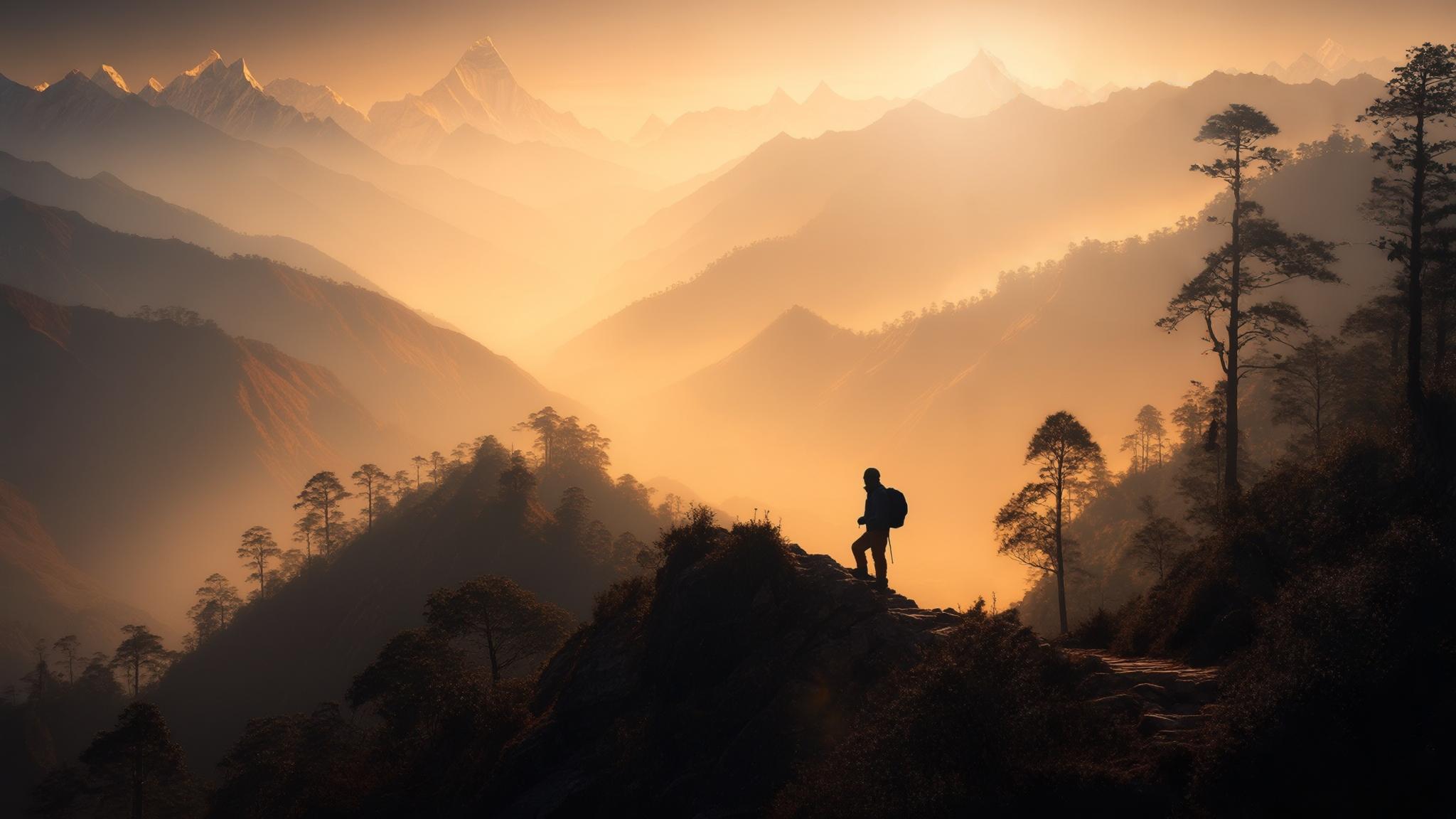
From the summit cairn, the view north includes identifiable peaks: Bandarpunch (6,316 m), Swargarohini (6,252 m), and on exceptionally clear days in winter, the Kedarnath massif. The Doon Valley spreads below to the south, with Dehradun’s urban sprawl visible approximately 30 kilometres away.
Getting There From Mussoorie’s Main Tourist Areas
Most visitors to Mussoorie stay near Mall Road, Library Chowk, or Landour — all of which are east of Park Estate. The simplest approach is a shared taxi or auto-rickshaw from Library Chowk to Park Estate, a 6-kilometre road journey that costs approximately ₹60–₹80 per person in a shared vehicle or ₹250–₹350 for a full cab as of early 2026.
Cyclists and motorcycle riders can continue past Park Estate directly on the road for another 1.5 kilometres before the track becomes impassable for two-wheelers. Parking near the estate is informal — a flat area of compacted earth accommodates roughly a dozen vehicles on busy days.
There is no established food vendor at the trailhead or on the route itself. The nearest tea stalls are clustered near the Park Estate junction, approximately 800 metres back down the road. Visitors who arrive early on weekend mornings occasionally find a vendor with chai and biscuits at the parking area, but this is not reliable.
How George Everest Peak Compares to Mussoorie’s Other Viewpoints
Mussoorie has several established viewpoints that draw consistent crowds — Lal Tibba, Camel’s Back Road, and the Cable Car to Gun Hill among them. Each charges admission, involves queuing during peak season, and delivers views shaped around infrastructure: observation platforms, guardrails, souvenir stalls. George Everest Peak offers none of these, which is precisely its appeal to a specific category of visitor.
According to the Uttarakhand Tourism Development Board, Mussoorie receives approximately 15 lakh visitors annually, with peak inflows during the April–June and October–November windows. The majority of this footfall concentrates on Mall Road and the Kempty Falls corridor. George Everest Peak, by contrast, attracts a smaller and more deliberate visitor segment: hikers, photographers, and travellers specifically seeking to avoid the commercial tourist belt.
Best Time to Go and What to Bring
The clearest Himalayan views occur between mid-October and early March, when post-monsoon haze has dissipated and pre-summer dust has not yet settled over the plains. February and early March combine clear visibility with rhododendron bloom along the lower sections of the trail, making this arguably the most visually rewarding window. Sunrise walks — starting the trail by 6:30 a.m. — consistently yield the clearest air before valley mist builds.
Summer months (April through June) bring warmer temperatures but significantly reduced visibility due to haze. The trail remains walkable, but the panoramic payoff diminishes substantially. Monsoon season (July through mid-September) makes the upper exposed section genuinely risky due to loose wet soil and reduced visibility; the Uttarakhand Forest Department has not formally closed the trail during monsoon but strongly advises against trekking in the area after rain.
The Historical Context Behind the Name
Sir George Everest served as Surveyor General of India from 1830 to 1843 and used the Mussoorie estate as a base for geodetic survey operations across the Himalayan foothills. His work establishing the arc of the meridian from the southern tip of India to Nepal formed the foundation for precise triangulation across the subcontinent. According to the Survey of India, his methods contributed directly to the calculation of the height of what was then called Peak XV — renamed in his honour in 1865, two years after his death.
Everest himself reportedly disliked the decision to name the peak after him, partly on the practical grounds that the name could not be easily pronounced by local populations in the region. The bungalow in Mussoorie is one of the few surviving physical connections to his time in India and sits on the same ridge he used for trigonometric observations of the northern horizon.
The ASI-protected ruins are not curated as a formal museum. There are no interpretive panels beyond the Survey of India plaque, no ticketed entry, and no guided tour infrastructure. For travellers with an interest in colonial scientific history, this lack of packaging is either a drawback or, depending on perspective, the most authentic aspect of the visit.
Frequently Asked Questions
{“@context”:”https://schema.org”,”@type”:”FAQPage”,”mainEntity”:[{“@type”:”Question”,”name”:”Is there an entry fee to visit George Everest Peak in Mussoorie?”,”acceptedAnswer”:{“@type”:”Answer”,”text”:”As of March 2026, there is no entry fee to access the George Everest Peak trail or the ASI-protected estate ruins at Park Estate, Mussoorie.”}},{“@type”:”Question”,”name”:”How long does the George Everest Peak trek take from Park Estate?”,”acceptedAnswer”:{“@type”:”Answer”,”text”:”The one-way trail is approximately 4 kilometres and takes roughly 90 minutes at a moderate walking pace, making the full round trip approximately 3 hours including time at the summit.”}},{“@type”:”Question”,”name”:”What is the best month to visit George Everest Peak for Himalayan views?”,”acceptedAnswer”:{“@type”:”Answer”,”text”:”Mid-October through early March offers the clearest visibility. February combines clear skies with rhododendron bloom along the trail’s lower section, making it a particularly recommended window.”}},{“@type”:”Question”,”name”:”How do I get to George Everest Peak from Mussoorie’s Mall Road?”,”acceptedAnswer”:{“@type”:”Answer”,”text”:”Shared taxis from Library Chowk to Park Estate (6 km) cost approximately ₹60–₹80 per person. A full cab costs ₹250–₹350. From Park Estate, the trail continues on foot for 4 kilometres to the summit.”}},{“@type”:”Question”,”name”:”Is the George Everest Peak trail safe during monsoon season?”,”acceptedAnswer”:{“@type”:”Answer”,”text”:”The Uttarakhand Forest Department advises against trekking the upper exposed section after rain due to loose wet soil. The trail is not formally closed during monsoon (July–mid September) but conditions are considered hazardous.”}}]}